I am a very goal oriented person, setting goals in my career as well as my activities helps foster motivation. I also like the idea of analyzing my efforts in order to see progress. Enter Strava, it's taken the cycling community by storm. Nearly every ride you can do on or off-road has been segmented and there is a leaderboard. I'll admit, sitting on top of the leaderboard feels pretty good even though you know there is still some faster guy who's not in the Strava community yet. I tracked every ride I did this past Summer with the goal of reaching 200,000ft of climbing, mostly on my MTB. I didn't quite make it before the snow flew and locked me out of the trails in the Wood River Valley.
Winter arrived and I needed a new goal, how about 100,000ft of ascent over the course of a Winter? That way I don't come out in the Spring a fat slob who can't pedal, it's happened. I of course turned to my favorite app, Strava, to keep track of my progress. What I found was that there are a few Backcountry people in my community and some Nordic who are using the app. Now I know somebody is going to write me feedback saying, "That's the point of the Backcountry, disconnecting from technology and experiencing the natural world." Or things to that affect. But here are some things to consider:
-Route finding is much easier between partners when they have a gps file of a recent tour and maps. Referencing ridge-lines or trees or whatever can lose a partner in the planning phase.
-When there is a community of people recording routes in the Backcountry there is physical evidence of use for land managers.
-You can tell a partner, a spouse or whomever you're relaying your location and return time to with accuracy where you'll be and how long you'll be out. (This has proven especially beneficial in my marriage, those "2-hour tours" that actually take 5 are very limited.
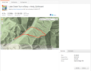
Here's a recent tour with data. Miles, Vertical Feet, Moving Time--
You can utilize satellite maps and export gpx files to handheld devices--
Where I live, we have what I like to call "Urban Backcountry". You still have 3G cell service during your entire tour. If you are using the Strava mobile app, you don't need a cell signal just a gps signal. In the future apps like these will be able to provide real time position externally available through your on-line profile. Endomondo already does this, your friend, spouse, whoever cares can track your position and even send text cheers like, "keep going" or "you'd better be home for dinner". These are actually made for things like cause rides/runs etc. But imagine the safety implications. If you weren't home by your intended time rescuers could find your position almost immediately. It's like having a wider spectrum on your beacon.
All activities are logged
-
-
I've heard some feedback that cell phones interfere with avalanche beacons, I'd like to know more about that. I'm also crazy about weight on my splitboard, and really wan to know how my set-up impacts my tour. I'm certain this technology has it's place in the Backcountry, and I don't think I'm, alone.
Here's my profile on Strava: http://app.strava.com/athletes/353200


No comments:
Post a Comment